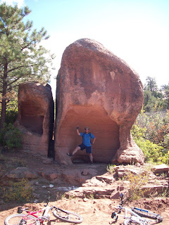
 We trained all summer and the day was finally here: the start of the Kokopelli Trail. My brother Larry and I planned to ride the 140 miles from Moab, Utah to Loma, Colorado in four days.
I snuck out of work Wednesday afternoon and headed for Grand Junction hoping that we could get two camp trailers set up and get to bed before it was too late. We dropped off my camp trailer at Dewey Bridge and everything was going as planned until Larry's transmission went out pulling mom's travel trailer up the steep road out of Castle Valley to Bull Draw. We left the trailer in the middle of the road and coasted in the pickup down to a spot where we could call my sister Veronica to come rescue us. She had not had much sleep, but her and James came and pulled the trailer to the campsite.
 We discussed whether we should still continue the ride, but Larry was determined.
The next morning I got to hold my new grand-niece for the first time. Aubrey is a beautiful little angel. Then James gave us a ride to the Slickrock trailhead. We felt pretty good even with little sleep and it was a beautiful day.
The Kokopelli trail does not necessarily include a trip around the famous Slickrock bike trail. It seemed a bit odd to instead ride our bikes up the well maintained dirt road. The slog up Sand Flats Road is not terribly exciting except for the scenery (photo 1). As you slowly crank your peddles you can see the shadow of every pebble on the road. This section involves hike-a-bike much of the time at least it did for us.
The single track ends once you reach Porcupine Rim. From here it is a never ending ride up a four wheel drive road as you try to get to the Loop Road. A couple of deer hunters on ATV's joked that we should be riding our bikes rather than pushing them. As you look down into Castle Valley you can see the burn area from a massive fire this summer 2008 (photo 3). You do encouner an old mine in this section and a truck from long ago.
Just when your quads have had about all the pump they can stand, you finally reach the La Salle Mountain Loop Road. From here your mountain bike turns into a road bike for the remainder of the trip to Bull Draw. After all that ascent the downhill on pavement through the aspens is liberating. My GPS clocked us at speeds up to 35 mph.
Once you hit Castle Valley Road the pavement starts back uphill for the final ascent of the day. After a couple of miles the road crosses a creek, so we stopped to clean up and cool off. The long and winding road seemed to last forever (photo 4). As each pickup or car passed us we questioned our mode of transportation (photo 5).
We finally made it to camp with about a half hour of daylight left. We payed our dues with the long and gruelling ascent and we looked forward the the descent on day two. James and Veronica came up to share our campfire and a celebration brew. A fitting end to day one!
We finally made it to camp with about a half hour of daylight left. We payed our dues with the long and gruelling ascent and we looked forward the the descent on day two. James and Veronica came up to share our campfire and a celebration brew. A fitting end to day one!


1 comment:
Props to yall! I know there is no way I could have done it!
Post a Comment